Maps
There are hundreds of maps in our collections. Copies of many of the maps are readily available elsewhere. Nevertheless, some of our map holdings are rare, including maps of North America and the polar region dating from the mid-sixteenth century to the nineteenth century which comprise part of the Robert Hunter fonds (87-001 and 99-004). Included are a number of maps of Canada and and the fonds especially emphasize historical maps of Ontario, Quebec and the Maritimes.
Our holdings also include a copy of the Sir Sandford Fleming 1846 Plan of the Town of Peterborough and, through the generosity of the Peterborough Centennial Museum and Archives, a copy of Romaine's Map of the Town of Peterborough and Village of Ashburnham, 1875.
Various maps of Peterborough, the region, and other areas are included in our Miscellaneous map collection and Miscellaneous folded map collection. You can also browse other maps and atlases in the Archives Database.
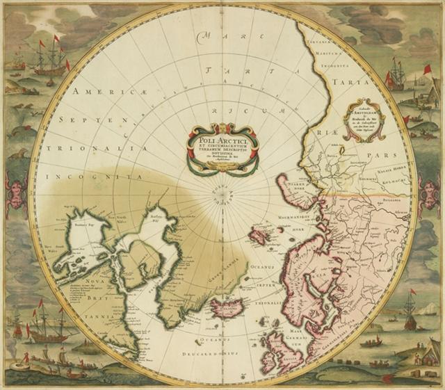
We have many rare and beautiful maps in the collection donated by Robert Hunter. One of the earliest is ca. 1556. It was drawn by Giacomo Gastaldi and is of Eastern Canada. Another Gastaldi map from 1565 shows America. Gastaldi also drew a map of Montreal dated 1565. It is entitled "Village of Hochelaga" but also uses the term "Monte Real" for the first time. One of the most attractive maps in the collection is by Frederick De Wit and shows the Arctic regions from a polar perspective. It was drawn in 1680. A reproduction of this map is available here.
Atlases
An assortment of Canadian and Ontario historical atlases are located in the Archives Reading Room.
Fire Insurance Plans
Fire insurance plans were produced by Chas. E. Goad & Co. between 1875 and 1923 but they have been updated from that time until 1974. They are an invaluable resource for homeowners, environmental assessors, city planners and architectural historians. Copyright regulation of all Fire Insurance Plans is stringent. Any duplication or publication in any form is the responsibility of the researcher and must be cleared through CGI Environmental Services in Markham, Ontario. Fire Insurance Plans show:
streets, lots, and buildings
- size, shape, construction materials, location on lot, height, and street addresses of buildings
- location of out-buildings, factory smoke stacks, piles of lumber and other industrial materials
NOTE: In addition to the Peterborough and area plans listed below, there is another group which dates from 1910-1972 and covers most of British Columbia and Ontario, and parts of Quebec, Alberta, Newfoundland and the Yukon.
Peterborough and Area Plans
- Beaverton, Ontario, July 1910
- Belleville, Ontario, February 1957
- Bowmanville, Ontario, June 1911, revised and reprinted Nov.1924
- Campbellford, Ontario, July 1926
- Cannington, Ontario, 1910
- Castleton, Ontario, April 1898
- Coboconk, Ontario, July 1910
- Cobourg, Ontario, reprinted March 1946 from a plan dated May 1919
- Colborne, Ontario, May 1934
- Hastings, Ontario, August 1911
- Lakefield, Ontario, September 1911
- Lindsay, Ontario, March 1949
- Norwood, Ontario, June 1900
- Oakwood, Ontario, June 1910
- Oshawa, Ontario, July 1966
- Peterborough, Ontario, August 1882
- Peterborough, Ontario, August 1882, revised to June 1889
- Peterborough, Ontario, revised in April 1911 from 1904
- Peterborough, Ontario, May 1929 revised to July 1943 revised to February 1948
- Peterborough, Ontario, September 1968
- Pickering, Ontario, December 1891
- Pontypool, Ontario, April 1904
- Port Hope, Ontario, December 1955
- Queensborough, Ontario, August 1904
- Stirling, Ontario, August 1911
- Trenton, Ontario, March 1949
- Victoria Road, Ontario, August 1898
- Warkworth, Ontario, June 1890
- Woodville, Ontario, July 1910
See also
The Maps, Data & Government Information Centre, also in the Bata Library, has many maps and atlases in their collections.