The Regional Environmental History Atlas (REHA) is a collaborative non-profit project involving Trent library staff, students, faculty and affiliated partners.
Project Objectives:
1. To create a regional portal and discovery tool for historical and current information including maps, imagery, spatial and statistical data, photographs, oral narrative and text and other resources about South Central Ontario.
2. To foster teaching and research encouraging new ways of looking at and understanding our region.
3. To encourage interdisciplinary collaborations and discussions within Trent University and externally with regional partners and members of the public. 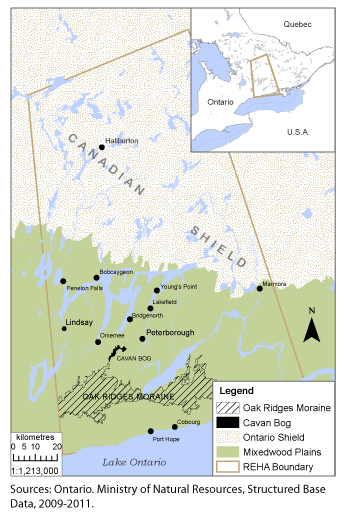
Geographic Coverage and Project Description:
The focus of this project is on South-Central Ontario: defined as an area extending from Lake Ontario in the south to Haliburton in the north, and from Oshawa in the west to Belleville in the east. This region, encompassing several counties and the Trent River watershed, is centered on Peterborough and Trent University, the home of the project. The region also encompasses several key themes in Canadian environmental history, including the expansion of agricultural and urban settlement in relation to natural and cultural features such as watercourses, railways, and roads; and, more generally, the evolution of land uses and economic activities, including resource extraction (logging and mining), agriculture, conservation (including reforestation), industrialization, and tourism. This evolution has occurred in the context of diverse array of landscapes, from fertile fields and forests near Lake Ontario to the northern Shield country.
The Atlas is intended to provide several kinds of resources for a broad group of researchers. One resource is access to existing information about the region's environmental history, through georeferencing and mapping of this knowledge. For example, an extensive effort has focused on locating and mapping the sites of over 300 mills in the Peterborough region. The resulting GIS layers can be useful in understanding settlement patterns in the region. In another aspect of the project, township histories have been reviewed, and information relevant to local environmental history has been extracted, located, and mapped.
The atlas will also serve as a digital archive of local historical information. We are currently seeking to make available historic topographical maps and historic aerial photos through scanning and georeferencing paper copies. These resources will serve a variety of researchers and purposes. For example, arranged as overlays, these resources can be used to study evolving patterns of land use and settlement.
This project is a work in progress. GIS and web services work, database development, and collections development, are being coordinated by Trent University Library's Maps, Data and Government Information Centre (MaDGIC) - past and present members: Geoff Andrews, Kate Hodge, Gabe Huebsch, Mike Kyffin, David Lang, Tracy Sallaway, Greg Young and Barbara Znamirowski. Lead consultant to the project, and project leader for environmental history content and analysis is Professor Stephen Bocking, Professor, Trent School of the Environment.
We would like to thank all members of of Trent University, local organizations and the public who have shared their historical understanding and insights about our region, contributed their research, assignments and collections to our database, and joined or expressed interest in our project.
Join Us:
The project welcomes all students, faculty, local organizations and members of the public to join us in this fascinating adventure and study of our region. Persons interested in web mapping technologies, Geographic Information Systems (GIS), Historical GIS (HGIS), depositing data or other information, or forming research collaborations are also invited to join the project.
Faculty, teaching assistants and graduate students wishing to involve their classes in the project are also most welcome to contact us.
For further information contact:
Tracy Sallaway, Research Data Services Librarian & Head, Maps, Data & Government Information Centre
Barbara Znamirowski, Librarian Emeritus, Maps, Data & Government Information Centre